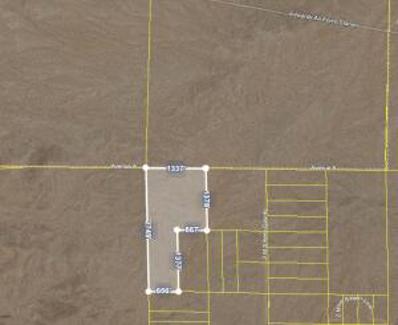
This 11.54 acre parcel is adjacent to the 395 Hwy. There is one portion of the parcel that is on the West side of the 395 and the majority of the parcel is on the East side adjacent to the parts yard. Approximately 330ft of frontage on the East and West side of the 395. This parcel is zoned Airport Development District+Cannabis. Property line markings are approximations. The use is described as follows and is very general. The Airport Development District (ADD) provides for a wide range of nonresidential uses, generally encompassing light and heavy industrial, retail, office, and other commercial uses that are oriented around airport operation, services, industries and businesses. The Airport Development District is intended to provide maximum flexibility to the City, landowners, and tenants in establishing and operating non-residential uses. Development is expected to be predominated by buildings of one (1) or two (2) stories, but may attain any heights up to fifty-five (55) feet . In some cases, retail uses will be on the ground floor, with offices above. All uses in this district will be required to execute aviation easements.
Investors and Developers take a look at these two parcels, 10 acre each, totaling 20 acres between the two parcels, (APN 3128-181-09-0000 & APN 3128-181-08-0000), Currently zoned R-S5, developing quickly. Residential to the South, and a proposed improved airport to Northeast with GE Pratt& Whitney Jet Engine Test Facility, Express and air freight terminal, Excellent for prime residential development location with the High Desert approved High Speed Train Victorville-Vegas expected to bring over 10,000 jobs boosting the economy and increasing the housing needs. Land is also located near the SCLA and the AMB Adelanto gateway and Frontier Homes just south of this lot, which is also near the Victoria Magathan Elementary School. Google maps coordinates are: 34.550414, -117.416779, Bring your offer today.
This parcel of land is located between Adelanto and Helendale. Easy road access. Buyer and Buyer's Agent to check all zoning/land use to satisfy themselves. East of Topaz Rd.
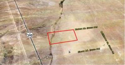
Huge land parcel! Over 61 acres of land! Great opportunity to acquire a large land position in Southern California at a very low price per acre. Very close to Edwards AFB, and not too far from 395 freeway. Very scenic desert area, with views of the buttes. Good secluded area for desert recreation, such as off-roading or camping. Great land-banking and investment opportunity, providing the ability to acquire a large chunk of land in the rapidly growing high desert area!
10 Acre of rural desert land located in Adelanto California. Scenic area with panoramic view of the Desert, Valley, and Mountain Range. Great location for recreational use, such as; camping, desert toy riding, or off the grid living etc. Priced to sell!! Located near proximity to El Mirage Dry Lake Bed, Kramer Junction and Silver Lake community. GPS Coordinates: 34.704820, -117.507241
10 Acre of rural desert land located in Adelanto California. Scenic area with panoramic view of the Desert, Valley, and Mountain Range. Great location for recreational use, such as; camping, desert toy riding, or off the grid living etc. Priced to sell!! Located near proximity to El Mirage Dry Lake Bed, Kramer Junction and Silver Lake community. GPS 34.70669, -117.50693
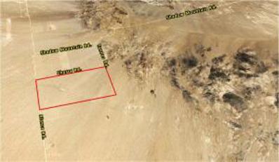
Large investment opportunity consisting of a total of 80+/- acres! This parcel is located just outside of the City Limits of Adelanto and in close proximity to U.S. Route 395 with electric transmission lines located within a mile West of the property. The nearest future Streets, as depicted on the assessors map, are Madera Rd., Bellflower St., and Sierra Rd. Electric service lines are currently along future Sierra Rd. being 1/4 mile away from the property. Currently zoned as RL-5 (Rural Living-5 Acre Minimum). Property may be in a flood zone as Fremont Wash affects parts of the Western portion of the property (buyer to verify).
Large investment opportunity consisting of a total of 320+/- acres! Located just 9 miles West of US Route 395 via Shadow Mountain Rd. in unincorporated San Bernardino County. The RC (Resource Conservation) land use zoning provides sites for open space and recreational activities, single family homes on very large parcels and similar and compatible uses. Zoning RC allows a density of 1 unit per 40 acres; accessory dwellings as allowed by San Bernardino County (buyer to verify).


Adelanto is located in California. Adelanto, California has a population of 37,229. Adelanto is more family-centric than the surrounding county with 35.2% of the households containing married families with children. The county average for households married with children is 33.94%.
The median household income in Adelanto, California is $58,040. The median household income for the surrounding county is $70,287 compared to the national median of $69,021. The median age of people living in Adelanto is 28.1 years.
The average high temperature in July is 98 degrees, with an average low temperature in January of 33.1 degrees. The average rainfall is approximately 6.1 inches per year, with 0.6 inches of snow per year.