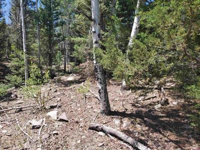
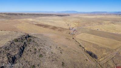
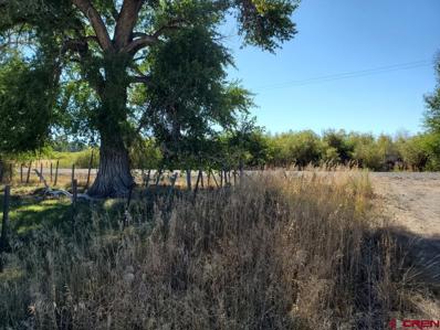
This 17.5-acre lot is heavily wooded with good roads on two sides. Located on the corner of North Rito Hondo Court and South Rito Hondo Court, there are several possible entrances for your driveway. This lot is more private with lesser views. Fully mature aspen, pine, juniper, and cedar ensure you'll be surrounded by trees and securely tucked into your own private world. Electricity to the lot line. Electricity to the lot line. Owner financing available. The owners have supplied first $3000 for the well and septic system. ($1,500 for well, $1,500 for septic.) This subdivision is surrounded by National Forest. The coordinates for lot 4B are: 37.01461, -106.21304 HOA Fees are $500 per year. Well permits for properties under 35 acres are under review by the Colorado Division of Water Resources. For more information, please contact Kip with the Colorado Division of Water Resources at ext. 3105. A nearby well (Lot 2) is 400 feet deep and produces 20gpm. Well Permit # 318075. This lot does not have a well already in place, this information is for depth and production reference only. Look for the covenants uploaded to the documents section. There are also virtual tours featuring this lot specifically as well as three fly-over drone videos. LOCATION: The Rito Hondo development is located approximately 10 miles west of Antonito, Colorado, on the south side of Hwy 17. Rito Hondo Club borders U.S. National Forest on all four sides and is roughly 1 mile North of the New Mexico Border in the center of the State. Antonito is 15 minutes by car, while a larger town, Alamosa, is 45 minutes and offers State of the art Medical with a New Hospital and life-flight services. Taos, NM is 1 hour 15 minutes, Santa Fe, NM is 2 hours away. DEEDED ACRES: Rito Hondo, as a whole, is approximately 630 acres M/L. and borders National Forest on all four sides. Several natural, year-round springs are scattered throughout the development, making this a year-round home for a variety of wildlife. TOPOGRAPHY: Each lot is different! Average elevation for the Rito Hondo development is 8,700â??. Flat meadows, steep hills, heavy trees, gorgeous views, this development has it all. Describe your favorite environment and we will find you the perfect lot. WILDLIFE: Elk, Deer, birds, all types of small & large game found in Colorado. ACCESS: Year around access of Hwy 17. Youâ??ll find paved roads out of Antonito for roughly 8 miles, Well maintained gravel roads for the last 2 miles. VIEWS: Panoramic views in all directions. These are truly spectacular properties with huge views and peace & quiet. IMPROVEMENTS: The development is fully fenced along the exterior where it borders National Forest. Large, ornamental gates secure both the North and South entrances. Excellent gravel roads are in place. Every lot has direct access to a main road except 13-F, which has an easement. Underground electricity is available at each lot line. WATER AND SEWER: Each lot owner will be required to install their own well and septic system. Conejos County does NOT require each septic system to be individually engineered, but they do require a soil test by a licensed contractor. The developers are offering $3,000 for both the well and septic for 35 acre lots (total $6,000), and $1,500 for both the well and septic for 17.5 and 6 acre lots (total $3,000). VEGETATION: Each lot is different, but the development â?? as a whole â?? includes stands of ponderosa pine, bristlecone pine, spruce, cedar, pinion, juniper, aspen and cottonwood trees. Lush mountain grass can be found on some of the lower lots near the natural springs.
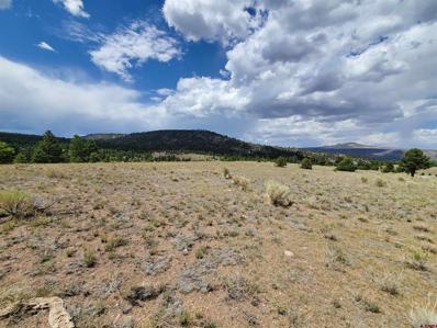
The hills are alive! This 17.5-acre parcel is the perfect spot for holding out your arms, spinning in circles, and admiring the wide-open views! Flat and easy to build, Lot 3A offers incredible views in all directions. Nothing to clear, no major excavating required, this lot is ready to build! Electricity to the lot line. Owner financing available. The owners will pay the first $3000 for the well and septic system ($1,500 for well, $1,500 for septic.) This subdivision is surrounded by National Forest. Look for the covenants uploaded to the documents section. There are also virtual tours featuring this lot specifically as well as a fly-over drone video. The Coordinates for Lot 3A are 37.01486, -106.20746 Well permits for properties under 35 acres are under review by the Colorado Division of Water Resources. For more information, please contact Kip with the Colorado Division of Water Resources at ext. 3105. A nearby well (Lot 2) is 400 feet deep and produces 20gpm. Well Permit # 318075. This lot does not have a well already in place, this information is for depth and production reference only. LOCATION: The Rito Hondo development is located approximately 10 miles west of Antonito, Colorado, on the south side of Hwy 17. Rito Hondo Club borders U.S. National forest on all four sides and is roughly 1 mile North of the New Mexico Border in the center of the State. Antonito is 15 minutes by car, while a larger town, Alamosa, is 45 minutes and offers State of the art Medical with a New Hospital and life-flight services. Taos, NM is 1 hour 15 minutes, Santa Fe, NM is 2 hours away. DEEDED ACRES: Rito Hondo, as a whole, is approximately 630 acres M/L. and borders National Forest on all four sides. Several natural, year-round springs are scattered throughout the development, making this a year-round home for a variety of wildlife. TOPOGRAPHY: Each lot is different! Average elevation for the Rito Hondo development is 8,700â??. Flat meadows, steep hills, heavy trees, gorgeous views, this development has it all. Describe your favorite environment and we will find you the perfect lot. WILDLIFE: Elk, Deer, birds, all types of small & large game found in Colorado. ACCESS: Year around access of Hwy 17. Youâ??ll find paved roads out of Antonito for roughly 8 miles, Well maintained gravel roads for the last 2 miles. VIEWS: Panoramic views in all directions. These are truly spectacular properties with huge views and peace & quiet. IMPROVEMENTS: The development is fully fenced along the exterior where it borders National Forest. Large, ornamental gates secure both the North and South entrances. Excellent gravel roads are in place. Every lot has direct access to a main road except 13-F, which has an easement. Underground electricity is available at each lot line. WATER AND SEWER: Each lot owner will be required to install their own well and septic system. Conejos County does NOT require each septic system to be individually engineered, but they do require a soil test by a licensed contractor. The developers are offering $3,000 for both the well and septic for 35 acre lots (total $6,000), and $1,500 for both the well and septic for 17.5 and 6 acre lots (total $3,000). VEGETATION: Each lot is different, but the development â?? as a whole â?? includes stands of ponderosa pine, bristlecone pine, spruce, cedar, pinion, juniper, aspen and cottonwood trees. Lush mountain grass can be found on some of the lower lots near the natural springs.
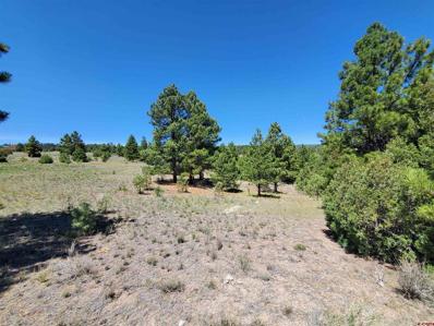
This 35-acre lot borders National Forest on two sides. Flat and open in the front, this lot slopes down into a deep canyon at the rear. Native, green, meadow grasses grow near the road, but once you move toward the middle and back of the lot, you'll find Ponderosa Pine, Aspen, and Juniper. This lot offers incredible views AND heavily wooded areas for privacy. Electricity to the lot line. Owner financing available. The owners will pay first $6,000 for the well and septic system ($3,000 well and $3,000 septic). A nearby well (Lot 2) is 400 feet deep and produces 20gpm. Well Permit # 318075. This lot does not have a well already in place, this is for depth and production reference only. This subdivision is surrounded by National Forest. GPS Coordinates for Lot 1 are 37.01922, -106.20320 HOA Fees are $500 per year Look for the covenants uploaded to the documents section. There are also virtual tours featuring this lot specifically as well as a fly-over drone video. LOCATION: The Rito Hondo development is located approximately 10 miles west of Antonito, Colorado, on the south side of Hwy 17. Rito Hondo Club borders U.S. National forest on all four sides and is roughly 1 mile North of the New Mexico Border in the center of the State. Antonito is 15 minutes by car, while a larger town, Alamosa, is 45 minutes and offers State of the art Medical with a New Hospital and life-flight services. Taos, NM is 1 hour 15 minutes, Santa Fe, NM is 2 hours away. DEEDED ACRES: Rito Hondo, as a whole, is approximately 630 acres M/L. and borders National Forest on all four sides. Several natural, year-round springs are scattered throughout the development, making this a year-round home for a variety of wildlife. TOPOGRAPHY: Each lot is different! Average elevation for the Rito Hondo development is 8,700â??. Flat meadows, steep hills, heavy trees, gorgeous views, this development has it all. Describe your favorite environment and we will find you the perfect lot. WILDLIFE: Elk, Deer, birds, all types of small & large game found in Colorado. ACCESS: Year around access of Hwy 17. Youâ??ll find paved roads out of Antonito for roughly 8 miles, Well maintained gravel roads for the last 2 miles. VIEWS: Panoramic views in all directions. These are truly spectacular properties with huge views and peace & quiet. IMPROVEMENTS: The development is fully fenced along the exterior where it borders National Forest. Large, ornamental gates secure both the North and South entrances. Excellent gravel roads are in place. Every lot has direct access to a main road except 13-F, which has an easement. Underground electricity is available at each lot line. WATER AND SEWER: Each lot owner will be required to install their own well and septic system. Conejos County does NOT require each septic system to be individually engineered, but they do require a soil test by a licensed contractor. The developers are offering $3,000 for both the well and septic for 35 acre lots (total $6,000), and $1,500 for both the well and septic for 17.5 and 6 acre lots (total $3,000). VEGETATION: Each lot is different, but the development â?? as a whole â?? includes stands of ponderosa pine, bristlecone pine, spruce, cedar, pinion, juniper, aspen and cottonwood trees. Lush mountain grass can be found on some of the lower lots near the natural springs.
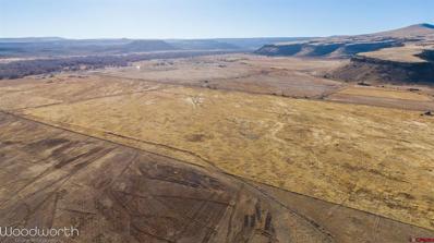
Irrigated Pasture ground that consists of 3 separate parcels totaling 97.05 acres. Property is being sold as a whole, but new owner has options as it is already subdivided. Property is being sold with 1.53 Shares of the Las Mesitas ditch. Property is fenced and is set up for flood irrigation with ditches. Great place to build a home or use for pasture. Priced at current apprised value. Call today for more details.
Irrigated Land that also borders BLM and the Poso State Trust Land. Currently, there is approximately 24 acres of alfalfa that is a 2 year old stand. New owner could farm another 16-18 acres. The terrain is sloping on the north and west sides and flat down in the bottom. Property has access to good big game hunting for elk and deer along with other small game. This property has 2.15 Shares of the Las Mesitas Ditch which allows the property to be flood irrigated during the irrigation season. This property has a lot of possibilities. Priced at appraised Value. Call today for more information.
Welcome home to your beautiful 40 acre parcel of land! The property is zoned as Rural Land by the county, so if you would like to develop the land, you would need to contact an engineer and the county to verify if that is possible. (There was previously a Mobile home and garage on the property closest to the fence as you enter the property.) There are deeded Water rights with this land. "Together with all ditch and ditch rights, Appurtenant to said land and as defined in WARRANTY DEED. Particularly 3 1/2 cubic feet per second of time in the Santiago ditch No.16, Priority NO.16 Water district #22" There is Electric and Septic available to hook up to. The land has been vacant for the last 4+ years, so you may want to have the electrical and septic updated if needed. There is a possible encroachment with the fence line, the well is on the side of encroachment. The sellers have leased out the land for the last few years to a private party for grazing. They terminated the grazing agreement once listed for sale.
3.7 acre parcel with private fishing access along the Conejos River. Just a hop and a skip from the Conejos River Anglers fly shop, this parcel is just off the beaten path and handy to everything. If you're looking for a place to build your dream cabin or just a spot to park your RV, this is the lot for you. Fiber internet to the property line. These opportunities are rare. Owner Financing available. Call for more information!

Antonito is located in Colorado. Antonito, Colorado has a population of 806. Antonito is less family-centric than the surrounding county with 23.83% of the households containing married families with children. The county average for households married with children is 32.63%.
The median household income in Antonito, Colorado is $25,800. The median household income for the surrounding county is $35,657 compared to the national median of $57,652. The median age of people living in Antonito is 41.4 years.
The average high temperature in July is 80.8 degrees, with an average low temperature in January of 4 degrees. The average rainfall is approximately 12.8 inches per year, with 31.8 inches of snow per year.