The median home value in Grouse Creek, UT is $468,600.
This is
higher than
the county median home value of $411,600.
The national median home value is $338,100.
The average price of homes sold in Grouse Creek, UT is $468,600.
Approximately 12.5% of Grouse Creek homes are owned,
compared to 14.58% rented, while
72.92% are vacant.
Grouse Creek real estate listings include condos, townhomes, and single family homes for sale.
Commercial properties are also available.
If you see a property you’re interested in, contact a Grouse Creek real estate agent to arrange a tour today!
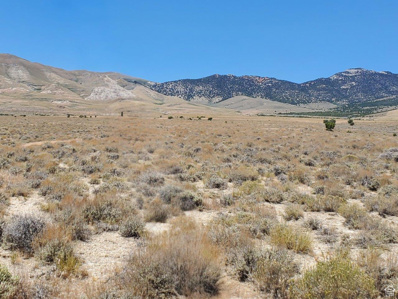
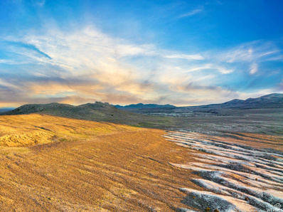
Over 161 acres of recreational land near the Utah/Nevada border. Get away from the hustle and bustle to your own oasis perfect for setting up your trailer to camp and ATV just outside the Great Salt Lake Desert. The area is filled with UTV trails for hiking, hunting and enjoying the scenery and wildlife. The property straddles Loop Rd with flat as well as mountainside terrain with views of the salt flats. Enjoy convenient access to Pilot Peak, Bald Eagle Mountain, McGinty Canyon, Betteridge Creek and the Sun Tunnels.
This property is not far from the Utah/Nevada border South of Lucin and about 5 miles West of the Sun Tunnels. To arrive at the property you take Hwy 30 and turn South onto Pilot Mountain Road. About 7 miles you come on Coal Bank Springs Road and follow that for about 2.5 miles. The property is about .25 miles south of Coal Bank Springs Road. There is no road directly to the property but the topography of the area is gentle rolling hills so a 4wd vehicle should be able to drive right up to the property. Along Pilot Mountain Road you see several landmarks, including the Transcontinental Railroad Line, Lucin Pond, and the Sun Tunnels are about 5 miles East of the property. Vegetation on the property includes Sagebrush, Prairie Grass, Wildflowers and Cactus. In the area I have seen rabbits, squirrel, lizards, Elk, Antelope and Deer. The property has great views of the Mountains to the East and the Salt Flats to the south. There are some rock outcroppings on the property. Soil is mostly sandy. There are no visible structures close to the property. There was a farm just north of the Sun Tunnels. The Sun Tunnels is a large - scale art installation. It consists of 4 large concrete cylinders, arranged on the desert floor in a cross pattern, that align with the sunrise and sunset on the summer and winter solstices. In addition to the solar framing, each of the cylinders has smaller holes representing the Draco, Perseus, Columba, and Capricorn constellations. The four concrete tubes act as viewfinders framing precise images which bring the vast space of the desert back to human scale. This would be a great property for someone who wants to be close to the mountains for recreation or wants to live off grid. The nearest towns with partial services are Grouse Creek to the North, and Montello, Nevada to the West. Wendover, Nevada to the south is the nearest town with full services. The property is Zoned Multi-Use 160. Seller has no water rights. No Utilities are in the vicinity. GPS Coordinates: 41.30625 - 113.96056
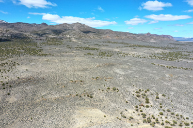
Own 40 acres of recreational land near the Utah/Nevada border and Lucin, UT Enjoy convenient access to Bald Eagle Mountain, Lion Mountain, and the recognizable outdoor artwork of Nancy Holt, known as the Sun Tunnels (four large concrete cylinders arranged on the desert floor in a cross pattern that align with the sunrise and sunset on the summer and winter solstices). A perfect area for UTV trails throughout the area or your RV/trailer to camp and soak up the views. County maintained gravel road approximately .5 miles from property and then a dirt road to and through the property itself. Approximately 6-10 acres of flat land with the remainder rolling hills. Wondrous adventures and memories await. Come take a look and fall in love. Buyer to verify all.
This property is not far from the Utah/Nevada border South of Lucin and about 5 miles West of the Sun Tunnels. To arrive at the property you take Hwy 30 and turn South onto Pilot Mountain Road. About 7 miles you come on Coal Bank Springs Road and follow that for about 2.5 miles. The property is about .25 miles south of Coal Bank Springs Road. There is no road directly to the property but the topography of the area is gentle rolling hills so a 4wd vehicle should be able to drive right up to the property. Along Pilot Mountain Road you see several landmarks, including the Transcontinental Railroad Line, Lucin Pond, and the Sun Tunnels are about 5 miles East of the property. Vegetation on the property includes Sagebrush, Prairie Grass, Wildflowers and Cactus. In the area I have seen rabbits, squirrel, lizards, Elk, Antelope and Deer. The property has great views of the Mountains to the East and the Salt Flats to the south. There are some rock outcroppings on the property. Soil is mostly sandy. There are no visible structures close to the property. There was a farm just north of the Sun Tunnels. The Sun Tunnels is a large - scale art installation. It consists of 4 large concrete cylinders, arranged on the desert floor in a cross pattern, that align with the sunrise and sunset on the summer and winter solstices. In addition to the solar framing, each of the cylinders has smaller holes representing the Draco, Perseus, Columba, and Capricorn constellations. The four concrete tubes act as viewfinders framing precise images which bring the vast space of the desert back to human scale. This would be a great property for someone who wants to be close to the mountains for recreation or wants to live off grid. The nearest towns with partial services are Grouse Creek to the North, and Montello, Nevada to the West. Wendover, Nevada to the south is the nearest town with full services. The property is Zoned Multi-Use 160. Seller has no water rights. No Utilities are in the vicinity. GPS Coordinates: 41.30625 - 113.96056